Garmin GPSMAP 65s Terrain Navigator (010-02451-11)
Preču attēliem ir ilustratīvs. Oriģinālais produkts var atšķirties, tāpēc, lūdzu, skatiet produkta specifikācijas preces aprakstā.
Noliktavā
Cena
€ 371.70E-veikala cena var atšķirties no veikalu cena.
Bezmaksas sūtīšana
Punkti ![]() +371
+371
Nomaksas
 no € 10.52 /mēnesī
 no € 10.52 /mēnesī
Garantijas periods24 mēneši
Piegādes laiks un iespējas
-
 2-4 dienas
 -
 2-4 dienas
 -
 2-4 dienas
 -
 2-4 dienas
 -
 2-4 dienas
Produkta apraksts
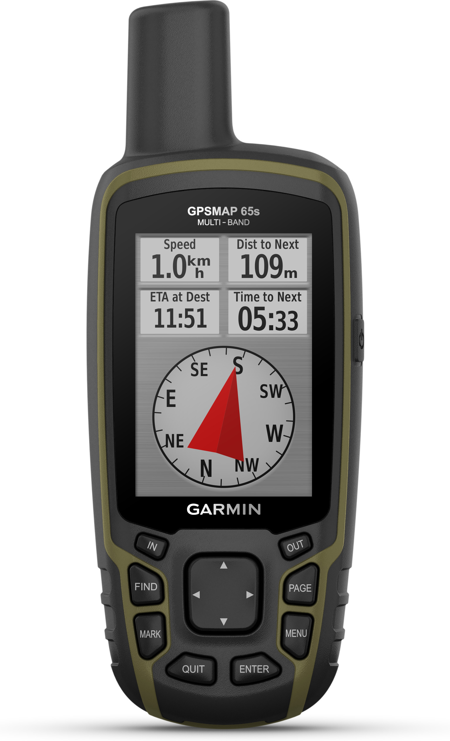
Explore the terrain with a reliable and versatile terrain navigator. The S model also includes a barometric altimeter and a three-axis compass.
The most important qualities:
- Includes barometric altimeter and three-axis compass
- Extended GNSS support - Multi-band technology and extended GNSS support (GPS, GLONASS, Galileo, QZSS and IRNSS) ensure optimum accuracy in steep terrain, urban canyons and rugged forests.
- Preloaded Topoactive Maps of Europe - Preloaded maps of Europe provide accurate information on, for example, street and terrain networks, waterways, natural features, land use areas and buildings.
- 5000 waypoint / favorite / location memory
- Log: 10,000 waypoints, 200 saved tracks
- Routes: 200, 250 points along the route, 50 points automatic routing
- Smart notifications - Receive emails, text messages, and alerts directly to your handheld when paired with a compatible device.
- Geocaching - Take advantage of Geocaching Live's automatic cache updates, such as descriptions, log information, and tips.
- Garmin Explore - Plan, evaluate, and sync waypoints, routes, and tracks with and on Garmin Explore. You can also evaluate performance on the terrain.
- Display: 2.6 ", 3.6 x 5.5 cm, 160 x 240 pixels, Transflective 65,000 color TFT touch screen
- Built-in memory: 16 GB
- MicroSD card slot - With a compatible device and microSD memory card, you can conveniently download TOPO 24K maps and set off. HuntView Plus maps, on the other hand, show the types and boundaries of state land and the names and boundaries of private landowners.
- Wireless connections: Bluetooth®, ANT + ®
- IPX7 rating
- Battery: 2 x AA (not included). The manufacturer recommends NiMH or LiIon batteries.
- Battery life: about 16 hours.
- Interface: miniUSB and NMEA 0183 interface
- Dimensions: 6.1 x 16.0 x 3.6 cm
- Weight: 217 g with batteries
In the sales package:
- GPSMAP 65s Terrain Navigator
- USB cable
- Guides